With the record-breaking flooding Ontario saw last spring likely to become more common, local agencies are working to reduce the impact and help residents prepare for emergencies.
The Grand River Conservation Authority’s focus is on mitigating flood events, while emergency responders plan for all contingencies.
The latest push for improvements stem from a report issued by a special advisor appointed by the Ford government following record-setting flooding earlier this year in the province.
Doug McNeil found much of the flooding was weather-related, caused by a combination of weather conditions: colder-than-average winter and spring, higher-than-average snowpack, lack of significant winter thaw, rapid snow melt and significant rain events in the spring. With forecasts predicting more severe weather due to climate change, his report laid out a number of steps to help the province become more flood resilient.
In this area, the first line of defence is the GRCA, with operates dams that help control water flows for the express purpose of avoiding floods, along with maintaining river levels during the dry months of summer. Or, what has traditionally been a dry time but has now changed, as witness by the late-June flooding incident in Woolwich and neighbouring communities back in 2017.
“Flooding is happening year-round,” said GRCA spokesperson Cam Linwood, noting such events are reserved to the spring-thaw period any longer. “We’ve had flooding in February; we’ve had flooding in June.”
Flood control and mitigation remains the top priority of the GRCA, he added.
In response to shifts in flooding events, the agency has been stepping up its use of technology to monitor the watershed, collecting more detailed imaging and mapping data to help predict where problems may occur.
It recently completed bathymetric LiDAR (Light Detection and Ranging) across large portions of the watershed. The technology creates a very detailed picture of the bed of local rivers and streams. When that information is combined with surface LiDAR data collected by the Ontario Ministry of Agriculture, Food and Rural Affairs and Ministry of Natural Resources and Forestry, it becomes an important tool in developing floodplain mapping in the watershed, the GRCA notes.
“We tend to rely on data. We are certainly seeing some additional climate volatility,” said Linwood, pointing to more frequent mid-winter melts.
The GRCA was part of McNeil’s review, providing feedback on flooding challenges and opportunities.
“Flood management remains a top priority for the GRCA with a focus on helping protect the lives and property of close to one million watershed residents,” said GRCA chief administrative officer Samantha Lawson in a statement. “We are grateful to have had the opportunity to provide input to Mr. McNeil, and we welcome his report shared by the Province. The recommendations reinforce the importance of a focused, collaborative approach in flood preparedness and responsiveness.”
A key part of the response to changing conditions are the community emergency management coordinators (CEMCs) from each of the municipalities in the region, along with the warning network known as AlertWR.
Woolwich CEMC Avril Tanner says the township has been busy preparing for flooding incidents ever since the June 2017 floods, which appeared to catch everyone off guard.
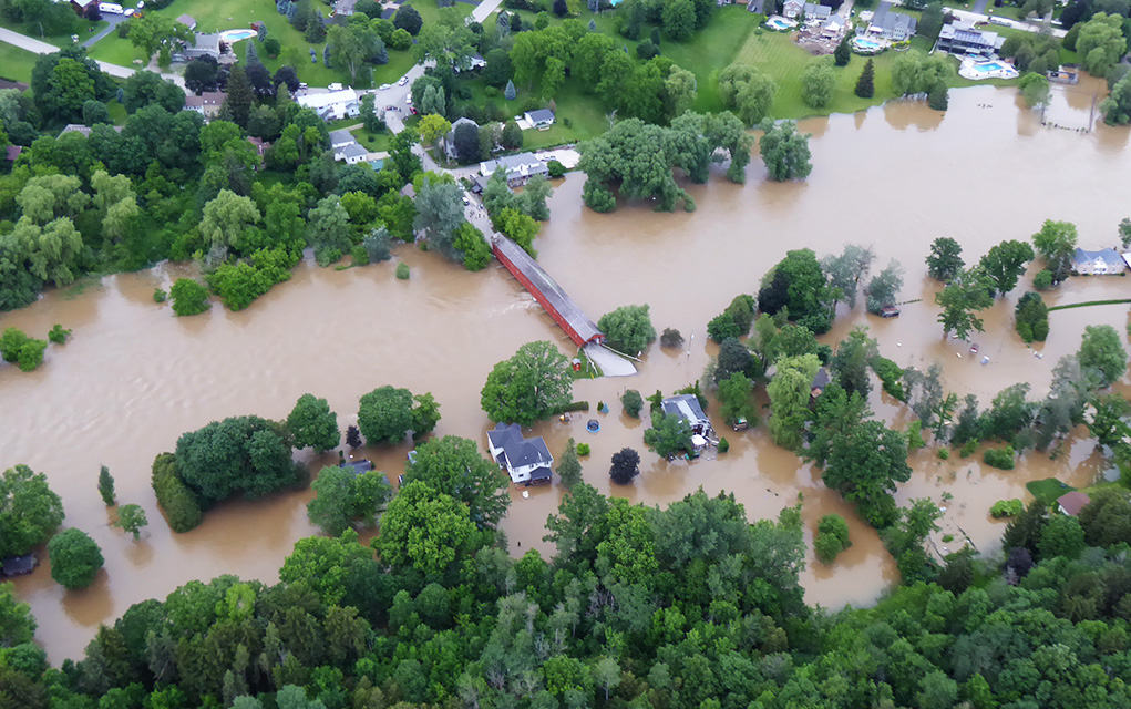
Heavy rainfall in the early morning hours in the north part of the Grand River watershed caused flooding downstream, including in the north end of Elmira. Significant flooding was seen in Floradale and points north, including Drayton and other parts of Mapleton Township. The rainfall to the north had the largest impact on the Grand and Conestogo rivers, with water volumes reminiscent of 1974, which saw significant flooding occur.
“We’ve been very busy since then,” said Tanner, noting area CEMCs are coordinating on planning and responses to future flooding events.
That includes being prepared for the worst, she noted.
“We’re planning for the worst-case scenarios, covering all of our bases.”
One such exercise involves the collapse of the Conestogo Lake dam northwest of Elmira. While the chances of that are low, the impact would be very big, she said.
To help prepare, emergency coordinators are making use of new data from the GRCA to shape their plans. The new mapping information, for instance, has identified more potential problem areas.
“That’s very helpful. We get to know the impacts of flooding before it happens,” said Tanner.
The township and other municipalities are also using technology to keep residents better informed about preparing for emergencies, tracking potential problematic weather and dealing with an emergency if flooding occurs. Education is key, she said, encouraging residents to be more aware and to have an emergency kit ready to go in advance of any problems.
“We look at ways of keeping residents informed … which includes knowing your risk,” she said, adding that some people are not even aware they’re at risk.
On the communication front, Linwood notes the GRCA is working with the municipalities to keep them better informed of developing concerns, an issue in the 2017 event.
“We continue to work closely with those municipal partners,” he said. “We’re looking to expand our means of notification.”