Much like the weather, predicting what kind of flooding the area might see as winter winds down is something of a guessing game. The Grand River watershed has already seen some flooding due to ice jams, and the up-and-down temperatures make likely a repeat of that situation, says the agency that monitors water levels.
The Grand River Conservation Authority last week hosted a meeting of local emergency coordinators to discuss pending risks and emphasize preparedness.
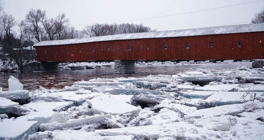
Just earlier this month, water and ice chunks from the Grand River washed up on properties in West Montrose, and similar incidents are likely.
“Looking at the forecast and that [weather] variability that exists – where we see those extreme highs and extreme lows, paired with the storm systems that move in – we are indicating that there is a moderate-to-high flood risk associated with snowmelt and rainstorm flooding for the spring,” said Cam Linwood, a GRCA spokesperson.
Snowmelt and unpredictable spring weather are likely to be at the root of any potential flooding. Jams are more likely as protracted deep freezes create more ice, sudden thaws weaken it and another round of freezing starts the cycle again.
“Because we have seen ice-jam flooding that has occurred this winter already, there are locations where there are still ice jams in the river system, and there’s still a high potential for ice to form because we’re still seeing some of those cold temperatures,” said Linwood.
In response, the GRCA notes it’s ready to send out flood messages should the situation occur, with residents to be notified through their municipal flood coordinators. Along with making public real-time monitoring of the river system and posting alerts, the GRCA also reaches out through various media.
Geographic information systems, including a version used by Waterloo Region Alert, are being used for the first time this year to help pinpoint at-risk areas.
“Preparedness is key, especially for those residents that do live within a floodplain or in those areas that are at a higher risk for spring flooding ,” said Linwood. “If you have any of those important items in your basements, you [should] have them out and out of the way.
“Certainly look at things like a 72-hour emergency kit – making sure you have one of those prepared. Listen and be proactive. Being aware of your surroundings and aware of what the river is doing.”
Such an emergency kit contains the likes of water, food, a flashlight, and a first-aid kit.
As part of the mitigation efforts, and partly in response to flash flooding that occurred in the summer of 2017, the GRCA keeps a close eye on water levels in its reservoirs. The idea is to have space behind its dams to take on any increased flows due to melting.
“So this time of year, our reservoirs are at a lower holding level,” said Linwood. “And what that does is it allows for some level of capacity to store that runoff. And then we’re able to release it following the event.”
Flood risk is not just a local issue but continues to be more widespread throughout the watershed. Around this time last year, a state of emergency was declared in Brantford due to flooding, and thousands of people were forced to evacuate.
“If we move downstream to Lake Erie, Lake Erie’s level right now is actually about 0.6 metres above the long-term average,” said Linwood. “So what that means for the southern part of their watershed, that would result in the potential for the higher risk of flooding right now. So the risk for the Lake Erie shoreline is high this year.”
The GRCA is part of the Provincial Flood Warning System. The agency monitors river flows, reservoir levels and weather in an attempt to stay on top of shifting flood conditions. Its website provides up-to-the-minute information important in forecasting floods and issuing flood warnings.